Geocachers, bikers, hikers, mountaineers - read on.
I'll describe the following things:
- where to get a (free) map
- how to create a custom map
- how to get the map onto your Garmin device
- how to convince your Garmin device to use your new map
Disclaimer
I'm not associated with Garmin Ltd. - and might not work with
Why should I want all this?
You want (custom, specialized) maps on your GPS device as you:
- like outdoor activities in unknown locations,
- own a Garmin device for GPS navigation,
- sometimes need *current* and free maps
Where to get a (free) map
Of course the OpenStreepMap would be the first place to go, unfortunately it is quite clumsy to get their data transformed into something legibly by a Garmin device.
Their data is awesome - but other people thankfully solved the issue of transforming it to appropriate formats… (kudos to Lambertus Ijsselstein for his incredible work!)
How to create a custom map
Point your browser to garmin.openstreetmap.nl -
a free service from Lambertus.
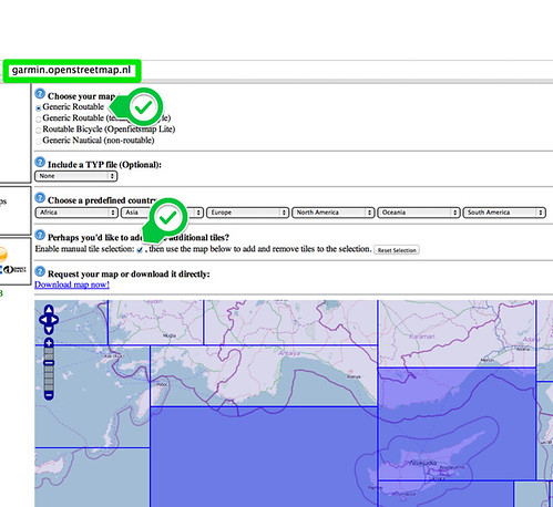
You stick with the default "generic routable" selection but enable the "manual tile selection".
Now you can choose whatever locations you need on the map. In the example above, I selected three rectangles (called tiles in geo-map-speak) for Cyprus.
Click on the "Download map now" link! Your custom map will now be generated (in the background) for you - that may take up to 24h, depending on the load they currently have.
You need to enter an email address, so that they can send you a download link… They won't spam you!
How to get the map…
After a while you'll receive a friendly mail containing a download link. For Garmin devices, you only need to download a single (zipped) file:
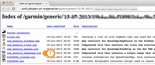
It's called "osm_generig_gmapsupp.zip" - ignore the strange name. Download and unpack to a folder of your choice.
There will be one single file in this archive. "gmapsupp.img". I recommend to rename the (unpacked) file to something you can remember - in my example I called it "cyprus.img".
You're close - but not finished yet. Have your Garmin device ready?
… onto your Garmin device
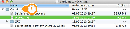
Plugin your USB cable or otherwise connect your Garmin.
Usually it is shown as disk.
You need to respect the Garmin directory name - it's "Garmin" spelled with capital "G"…
Every "*.img" file you copy into this directory can be used as a map… Too bad your Garmin device does not pick those up automatically…
How to convince your Garmin device to use your new map
Turn on your Garmin device and navigate to the "Maps" screen (shown here for a GPSmap 62s). Select "Menu":
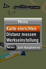
Select the "Setup Map" (on the screenshot above you see German version, "karte einrichten"):
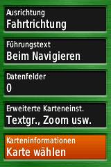
You now need to select the appropriate maps:
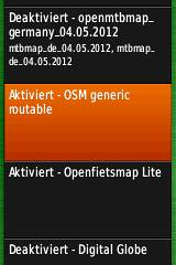
Your Garmin now display a list of all available maps. Usually all the OpenStreetMap maps are called "OSM generic".
It's advisable to deselect many (or all) of the other maps - as Garmin gets confused if several maps cover the same GPS coordinates…
(just in case you're adventurous: You can patch the "img" file to contain a better name - fire up a (hex/binary) editor and just replace the characters "OSM generic routable" by a name of your choice")